Cyclone Wati reaches Category 2 as Aitutaki braces for damaging winds on Sunday
Cyclone Wati has strengthened to Category 2 and is tracking southeast towards Aitutaki. The Cook Islands Meteorological Service reports average winds of 85 km/h (53 mph) with gusts up to 120 km/h (75 mph). The worst conditions on Aitutaki are expected from early Sunday morning local time, around 5 p.m. Sunday in the UK.

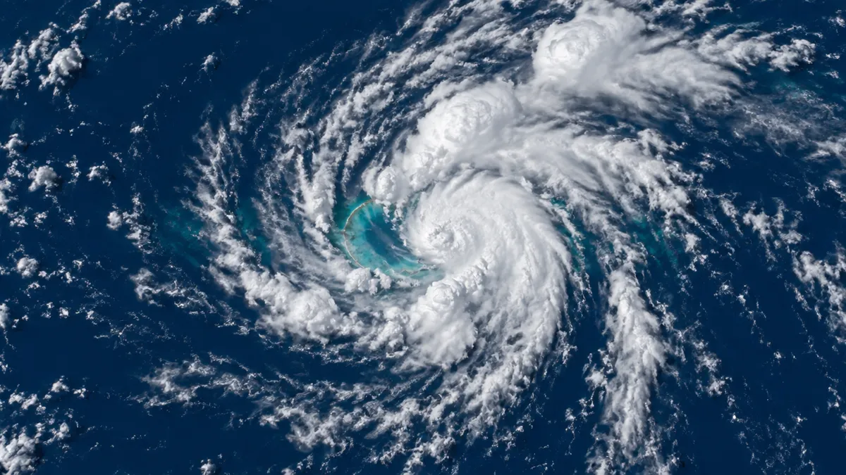
Update, October 17 (evening): Wati is now Category 2
Wati keeps getting stronger. The Cook Islands Meteorological Service now rates it a Category 2 cyclone with average winds of 85 km/h and gusts up to 120 km/h. Fiji’s RSMC Nadi, in its advisory issued at 06:56 UTC on Saturday, put sustained winds at about 50 knots, pressure at 989 hPa and motion to the southeast. By Sunday it is forecast to reach about 65 knots, the threshold of Category 3 on the Australian scale.
- Aitutaki: tropical cyclone alert. Heavy rain and squally thunderstorms from Saturday, then damaging gales of 85 km/h gusting to 120 km/h and high seas from early Sunday morning local time.
- Rest of the Southern Cooks, including Rarotonga: winds up to 45 km/h, gusts to 90 km/h, very rough seas from Sunday.
- Suwarrow: Wati passed the atoll as a Category 1 storm on Thursday. The rangers are safe, though erosion was noted around Anchorage Island.
Aitutaki has a command post at the power station staffed around the clock, almost every boat has left Arutanga marina, and hotels were asked to cancel Saturday tours. The Australian Bureau of Meteorology also warns of heavy rain and dangerous rip currents around the Cook Islands and Tahiti this weekend. No damage had been reported by Saturday evening.
Update Oct 17: the depression is now Cyclone Wati
On Friday morning, October 16, local time, RSMC Nadi upgraded TD01F to a Category 1 tropical cyclone and named it Wati. It is the first cyclone of the new season, about two weeks before the official start on November 1.
- Strength: sustained winds near the center around 74 km/h (40 knots), pressure 994 hPa.
- Movement: southeast at about 15 km/h, toward the Southern Cook Islands.
- Forecast: winds up to about 111 km/h (60 knots) by 8 a.m. Saturday local time, meaning Category 2 near Suwarrow and Aitutaki, then weakening as Wati heads toward French Polynesia.
- Palmerston and Aitutaki: cyclone alert, with damaging gale-force winds possible from later Saturday local time.
New Zealand’s NIWA says Wati poses no threat to New Zealand.
Where the system is
At 8 a.m. local time on Thursday, October 15, the Cook Islands Meteorological Service placed the depression about 352 km (220 miles) north of Suwarrow, moving south and expected to curve south-southeast. GDACS’s latest fix, at 18:00 UTC Friday, already had it close to the atoll at 12.7°S, 163.4°W.
Warnings in force
- Suwarrow: tropical cyclone warning - damaging gales, heavy rain, squally thunderstorms and very rough seas.
- Palmerston and Aitutaki: cyclone alert, worsening weather over the next 24-30 hours.
- Pukapuka, Nassau and the other islands: strong winds, heavy rain and rough seas.
The forecast track points toward the Southern Cook Islands. Rarotonga, home to most of the population, is expected to sit on the edge of the system.
What officials advise
Secure loose items, check emergency supplies, and keep boats in harbour if conditions turn unsafe. Fiji’s RSMC Nadi will name the system if it reaches cyclone strength, and the Cook Islands Meteorological Service issues local updates.
See it live
FAQ
When will Cyclone Wati hit Aitutaki in US and UK time?
The Cook Islands are on UTC-10. Heavy rain and thunderstorms begin on Saturday, and damaging gales (85 km/h average, gusts to 120 km/h) are forecast from early Sunday morning local time, which is roughly noon Sunday EDT and 5 p.m. Sunday in the UK. Fiji Met expects the cyclone itself to peak between about 8 p.m. Saturday and 2 a.m. Sunday EDT.
How strong is Cyclone Wati now?
In the RSMC Nadi advisory issued at 06:56 UTC on Saturday, October 17, Wati had sustained winds of about 50 knots (93 km/h, 58 mph) and a central pressure of 989 hPa. It was moving southeast at about 8 knots and still intensifying, with 65 knots (120 km/h) forecast within a day. GDACS keeps an orange alert with winds up to 130 km/h.
Is a cyclone in October unusual?
Yes, it is early. The official South Pacific cyclone season starts on November 1. Earth Sciences New Zealand has forecast elevated cyclone activity for parts of the Pacific this season.
Sources
- Cook Islands Meteorological Service
- RSMC Nadi - Fiji Meteorological Service
- GDACS - Tropical Cyclone ONE-26
- RNZ Pacific / Scoop - Cyclone alert in force for Cook Islands (16.10.2026)
- Cook Islands News - TD01F upgraded to Category 1 Tropical Cyclone Wati (16.10.2026)
- Fiji Meteorological Service - TC Advisory Wati 2026/3 (17.10.2026, 06:56 UTC)
- Cook Islands News - Bracing for Wati: Category Two cyclone bears down on Aitutaki (17.10.2026)
All guides
 Cyclone Arnab heads for India: landfall in Andhra Pradesh expected Wednesday morning
 Deep M6.5 earthquake near the Bonin Islands, Japan - October 25, 2026
 Vanuatu earthquake: M6.9 quake and tsunami warning on October 24, 2026
 Earthquake in Italy today: M5.0 off the Aeolian Islands near Sicily on October 23, 2026